Press Release: 10/21/2026
City of Boston Launches Coastmix
BOSTON – October 21, 2026 – Today, the City of Boston’s Office of Climate Resilience and Office of Emerging Technology launched Coastmix, an interactive website that allows users to design and explore ways to protect coastlines from sea level rise. The tool is now available online at coastmix.org. Users can visit boston.gov/coastmix to learn more about the platform, watch a how-to tutorial, and submit to a community gallery of Coastmix designs. The City of Boston is also hosting an online webinaron Friday, November 6 from 12-1 PM EST to demonstrate Coastmix’s uses and answer questions about the platform.
Across the world, coastal cities like Boston are facing the impacts of climate change as sea levels rise and extreme weather events become more frequent and severe. As the City of Boston implements coastal resilience plans along its entire 47-mile coastline, it has sought creative ways to engage with residents who may be unfamiliar with what the City can build along our coastline to protect neighborhoods from flooding. Coastmix was created to serve as an innovative community engagement and education tool not just for Boston residents, but also for researchers, organizers, students, and coastal communities around the world.
Coastmix is built using the same interface as Streetmix, a popular transportation planning tool created after a Code for America hackathon in 2013. In Coastmix, users can re-create a real-world coastal environment and modify it with possible design features to protect the surrounding area from flooding. Tools of this kind have been used by organizations across the United States to engage citizens around streetscape and placemaking issues, including the Project for Public Spaces and National Complete Streets Coalition. A user’s design choices reflect the opportunities, space constraints, and trade-offs of various flood prevention strategies. Features of Coastmix include:
- Drag-and-Drop Interface: Users can add, remove, or rearrange street elements like vehicle lanes, bike lanes, and sidewalks, as well as coastal resilience infrastructure like berms, dunes, floodwalls, nature-based solutions, and more.
- Example waterfront environments: Coastmix contains optional preset examples that users can select from a gallery and build their designs on.
- Projected sea level rise: Users can add flooding into their designs to see if they will protect a community against flooding based on sea-level rise and storm surge projections in 2030, 2050, or 2070.
- Sharing and Collaboration: Coastmix allows users to download and share their designs.
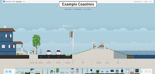
A screenshot of the Coastmix interface, including the mockup of an elevated harborwalk and berm designed to prevent coastal flooding.
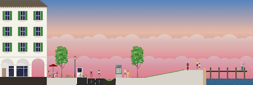
A sample Coastmix design of a berm and seawall.
“Our coastal resilience planning and implementation efforts have always involved community engagement and education, and the motivation to create Coastmix came from a desire to bring residents closer to the design process,” said Catherine McCandless, Senior Climate Resilience Project Manager, Office of Climate Resilience. “Coastmix will enable us to explain and demonstrate coastal resilience concepts as an education tool, envision possible adaptation strategies with partners and community members, and explore opportunities and tradeoffs to inform the decision-making process for future work.”
"Streetmix is a classic civic technology tool, used by tens of thousands of planners and community members around the world," said Michael Lawrence Evans,Director of the Office of Emerging Technology. "Coastmix brings that same creative, accessible approach to coastal resilience, making it easier and more engaging for anyone to explore how we protect our waterfront."
“Our mission with Streetmix has always been to bring city planners and community stakeholders together to collaborate on ideas for public spaces, and building our waterfronts is a natural extension of that mission.“ says Lou Huang, Project Lead of Streetmix.“Especially as climate change and sea level rise has the potential to impact neighborhoods and thousands of residents, we are honored to work with the City of Boston, the Office of Climate Resilience and the Office of Emerging Technology to bring our fun yet educational approach to real-world planning solutions.”
The code powering Coastmix is open source and publicly available at https://github.com/OETBoston/Coastmix. Other emerging technology projects tackling climate action and pollution mitigation, including Common SENSES, Boston’s densest environmental sensor network, and Project Green Light, can be found at boston.gov/oet.
The City of Boston is taking action to prepare for the impacts of climate change. Learn more about the City's coastal resilience work at boston.gov/climate-resilience.